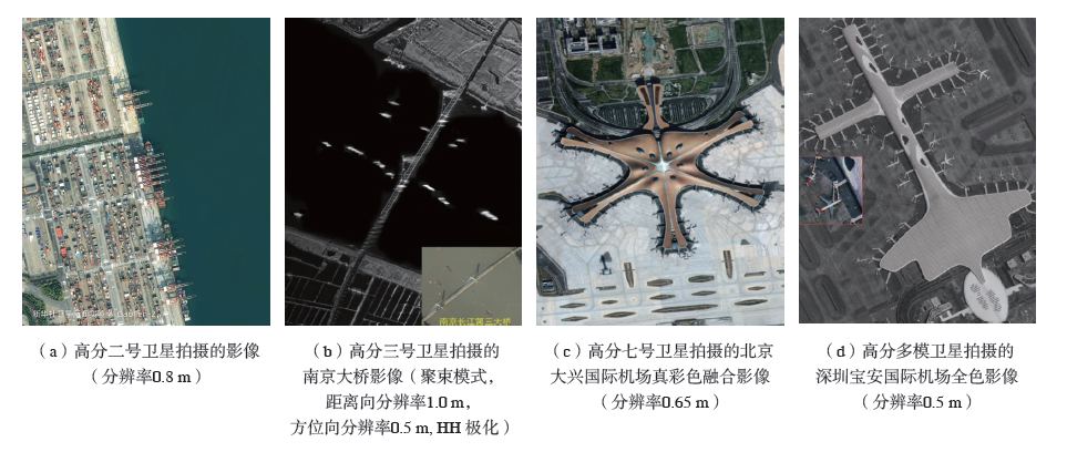
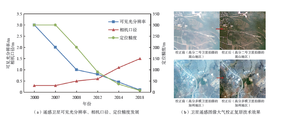
| [1] |
李劲东. 空间科学. 卫星遥感技术: 上册[M]. 北京: 北京理工大学出版社, 2018.
|
| [2] |
马聪丽. 高分辨率测绘卫星应用及其标准建设研究初探[J]. 地理空间信息, 2020, 18(5):8-13.
|
| [3] |
孙伟伟, 杨刚, 陈超, 等. 中国地球观测遥感卫星发展现状及文献分析[J]. 遥感学报, 2020, 24(5):479-510.
|
| [4] |
金亚秋. 微波遥感及其在中国的发展[J]. 微波学报, 2020, 36(1):1-6.
|
| [5] |
张庆君, 韩晓磊, 刘杰. 星载合成孔径雷达遥感技术进展及发展趋势[J]. 航天器工程, 2017, 26(6):1-8.
|
| [6] |
李劲东, 乔凯, 杨冬. 高分辨率光学遥感卫星在轨成像质量设计与验证[M]. 北京: 国防工业出版社, 2021.
|
| [7] |
Chuvieco E, Huete A. Fundamentals of satellite remote sensing[M]. Boca-Raton: CRC Press, 2009.
|
| [8] |
梁晓珩, 梁秀娟, 柯蓓. 我国遥感卫星系统发展进阶路径探讨[J]. 航天器环境工程, 2021, 38(1):100-105.
|
| [9] |
李忠宝. 遥感卫星系统及其应用的发展与思考[J]. 卫星应用, 2014(11):23-29.
|
| [10] |
赵文波, 李帅, 李博, 等. 新一代体系效能型对地观测体系发展战略研究[J]. 中国工程科学, 2021, 23(6):128-138.
|
| [11] |
姜景山, 王涛. 中国空间探测的回顾与展望——造福全人类面向未来的中国空间探测[J]. 中国工程科学, 2008, 10(6):4-9.
|
| [12] |
廖小罕. 中国对地观测20 年科技进步和发展[J]. 遥感学报, 2021, 25(1):267-275.
|
| [13] |
赵文波. “中国高分”科技重大专项在对地观测发展历程中的阶段研究[J]. 遥感学报, 2019, 23(6):1036-1045.
|
| [14] |
赵志远. 强强联手的“高分”家族[J]. 太空探索, 2021(3):15-17.
|
| [15] |
国际宇航科学院院士童旭东谈“天眼工程”:中国的高分专项,让中国航天更辉煌[N]. 新华日报, 2021-12-08(12).
|
| [16] |
新华社年度卫星影像:2021奋进的中国[EB/OL]. [2021-12-27]. http://www.news.cn/politics/2021-12/27/c_1128204705.htm.
|
| [17] |
高分三号卫星及其拍摄的地面影像[J]. 航天器工程, 2017, 26(6):2-14.
|
| [18] |
高分七号卫星首批亚米级立体影像产品发布[EB/OL]. [2019-12-10]. http://www.cnsa.gov.cn/n6758823/n6758838/c6808401/content.html.
|
| [19] |
高分多模卫星影像产品[J]. 航天器工程, 2021, 30(3):9-20.
|
| [20] |
白照广, 陆春玲, 李长俊, 等. 高分一号卫星系统总体技术[C]//中国宇航学会, 中国科学院电子学研究所. 第二届高分辨率对地观测学术年会论文集. 北京: 中国地图出版社, 2013.
|
| [21] |
刘洋, 李进喜, 王春发, 等. “高分二号”卫星双相机影像几何拼接方法[J]. 航天返回与遥感, 2021, 42(5):67-75.
|
| [22] |
姜洋, 范立佳, 于龙江, 等. 高分多模卫星图像定位精度保证设计与验证[J]. 航天器工程, 30(3):69-75.
|
| [23] |
张庆君. 高分三号卫星总体设计与关键技术[J]. 测绘学报, 2017, 46(3):269-277.
|
| [24] |
刘建强, 安文韬, 梁超, 等. 高分三号卫星在应急监测中的应用[J]. 卫星应用, 2021(9):33-40.
|
| [25] |
刘畅, 白强, 唐高, 等. 中国海洋遥感技术进展[J]. 船舶与海洋工程, 2018, 34(1):1-6.
|
| [26] |
林明森, 何贤强, 贾永君, 等. 中国海洋卫星遥感技术进展[J]. 海洋学报, 2019, 41(10):99-112.
|
| [27] |
王殿中, 何红艳. “高分四号”卫星观测能力与应用前景分析[J]. 航天返回与遥感, 2017, 38(1):98-106.
|
| [28] |
孙允珠, 蒋光伟. “高分五号”卫星概况及应用前景展望[J]. 航天返回与遥感, 2018, 39(3):1-13.
|
| [29] |
Liu Y N, Sun D X, Hu X N, et al. The advanced hyperspectral imager: Aboard China’s Gaofen-5 satellite[J]. IEEE Geoscience and Remote Sensing Magazine, 2019, 7(4):23-32.
DOI
URL
|
| [30] |
陆春玲, 白照广, 胡志勇, 等. 高分六号卫星技术创新与应用成果[J]. 卫星应用, 2020(12):12-17.
|
| [31] |
陆春玲, 白照广, 李永昌, 等. 高分六号卫星技术特点与新模式应用[J]. 航天器工程, 2021, 30(1):7-14.
|
| [32] |
胡柳茹, 唐新明, 张智, 等. 高分七号卫星多源遥感数据精度优化与评估[J]. 红外与激光工程, http://kns.cnki.net/kcms/detail/12.1261.TN.20211102.1615.006.html.
|
| [33] |
唐新明, 刘昌儒, 张恒, 等. 高分七号卫星立体影像与激光测高数据联合区域网平差[J]. 武汉大学学报(信息科学版), 2021, 46(10):1424-1430.
|
| [34] |
曹海翊, 张新伟, 赵晨光, 等. 高分七号卫星总体设计与技术创新[J]. 中国空间科学技术, 2020, 40(5):1-9.
|
| [35] |
唐新明, 胡芬. 卫星测绘发展现状与趋势[J]. 航天返回与遥感, 2018, 39(4):26-35.
|
| [36] |
夏天, 张文慧. 高分多模卫星[J]. 卫星应用, 2020(8):4.
|
| [37] |
范立佳, 王跃, 杨文涛, 等. 高分多模卫星方案设计与技术特点[J]. 航天器工程, 2021, 30(3):10-19.
|
| [38] |
中国科学院长春光学精密机械与物理研究所. 4米量级高精度SiC非球面反射镜制造系统[J]. 中国科学院院刊, 2018, 33(Z1):52-55.
|
| [39] |
金亚秋. 微波遥感及其在中国的发展[J]. 微波学报, 2020, 36(1):1-6.
|
| [40] |
宋皓薇. 我国将迎来陆地探测卫星网络——航天科技集团陆地探测一号01组卫星研制侧记[N]. 中国航天报, 2022-01-28(3).
|
| [41] |
楼良盛, 刘志铭, 张昊, 等. 天绘二号卫星工程设计与实现[J]. 测绘学报, 2020, 49(10):1252-1264.
|
| [42] |
刘韬. 国外商业遥感的新进展[J]. 卫星应用, 2014(12):34-37.
|
| [43] |
朱良, 郭巍, 禹卫东. 合成孔径雷达卫星发展历程及趋势分析[J]. 现代雷达, 2009, 31(4):5-10.
|
| [44] |
常际军. 合成孔径雷达卫星的技术发展现状及趋势[C]// 中国宇航学会飞行器总体专业委员会2006年学术研讨会. 2006: 17-25.
|
| [45] |
张润宁, 王旭莹, 王志斌. 星载高分宽幅SAR技术发展趋势分析[J]. 航天器工程, 2022, 31(1):1-9.
|
| [46] |
张润宁, 王国良, 梁健, 等. 空间微波遥感技术发展现状及趋势[J]. 航天器工程, 2021, 30(6):52-61.
|
| [47] |
李忠宝. 遥感卫星系统及其应用的发展与思考[J]. 卫星应用, 2014(11):23-29.
|
| [48] |
李德仁. 论“互联网+”天基信息服务[J]. 遥感学报, 2016, 20(5):709-714.
|
| [49] |
李德仁, 沈欣. 我国天基信息实时智能服务系统发展战略研究[J]. 中国工程科学, 2020, 22(2):138-143.
|