前瞻科技 ›› 2022, Vol. 1 ›› Issue (2): 103-120.DOI: 10.3981/j.issn.2097-0781.2022.02.008
收稿日期:2022-05-20
修回日期:2022-06-02
出版日期:2022-06-20
发布日期:2022-08-18
作者简介:陈戈,教授,博士研究生导师。现任中国海洋大学海洋信息技术教育部工程研究中心主任。国家杰出青年科学基金获得者,教育部“长江学者”特聘教授,青岛海洋科学与技术试点国家实验室“新一代海洋科学卫星”首席科学家。主要研究方向为非线性海洋涡旋的形态学、运动学和动力学遥感研究;新一代海洋科学卫星的设计与研制;基于广义AI技术的大数据海洋学与孪生海洋研究。电子信箱: gechen@ouc.edu.cn。
基金资助:
CHEN Ge1,2,3( ), YANG Jie1,3, WU Lixin2,4
Received:2022-05-20
Revised:2022-06-02
Online:2022-06-20
Published:2022-08-18
摘要:
从百米到千米尺度的中层海洋是地球系统中极为关键而又缺乏认知的部分,许多重要的海洋过程都发生于此。在传统海洋学理论和现场观测相对缺乏的背景下,如何“由表及里”地从太空“遥感”中层海洋是一个极具挑战性的科学问题。人工智能搭建了数据科学与海洋科学的新桥梁(称之为“深蓝AI”),是推动元宇宙时代海洋科学范式变革的有力武器。文章首先阐述了百米海洋的水体运动与千米海洋的垂直层化等基础先验知识,以及卫星遥感、现场观测等技术手段为深蓝AI提供的数据资源;然后从关联统计、物理牵引和数学驱动3个神经网络层面着重论述了为实现中层海洋遥感而构建的深蓝AI普适方法论;最后围绕典型海洋动力过程,阐述了深蓝AI技术在挖掘海洋数据空间共性规律,进而实现“由表及里”的知识发现等方面所具有的独特优势和应用潜力。
陈戈, 杨杰, 吴立新. 人工智能支持下的中层海洋遥感技术[J]. 前瞻科技, 2022, 1(2): 103-120.
CHEN Ge, YANG Jie, WU Lixin. Artificial Intelligence-aided Remote Sensing of the Intermediate Ocean[J]. Science and Technology Foresight, 2022, 1(2): 103-120.

图1 海洋中各种类型运动的时间尺度、空间尺度及深度

图2 百米深度主被动遥感与现场联合观测一体化概念设计图

图3 海洋水体垂直分层
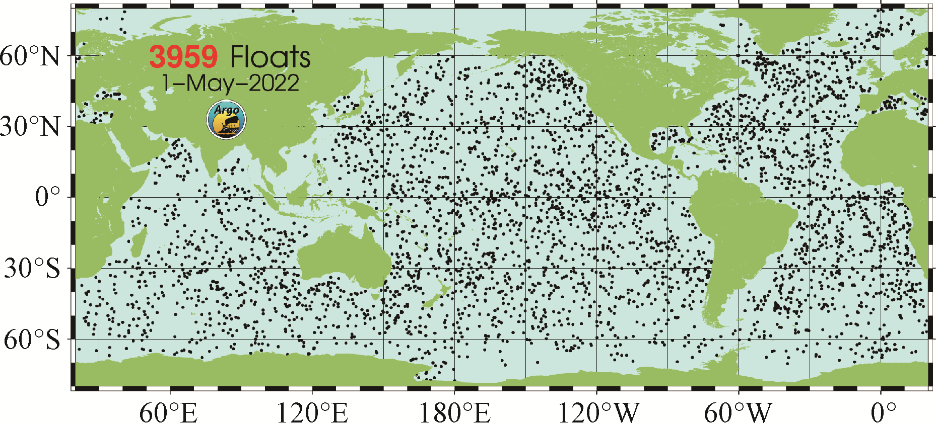
图4 Argo全球海洋观测网分布图 (来源:https://argo.ucsd.edu/)

图5 基于Argo测量的拉布拉多海温度剖面

图6 深蓝AI的哲学思想与科学构想

图7 卷积神经网络中卷积计算过程示意图 输入数据(如海洋环境参数海洋高度异常、海表面温度等)通过卷积核进行卷积计算得到数据的特征图,特征图引入偏置值(b),并进行激活函数(ReLU)线性运算,得到最终结果。
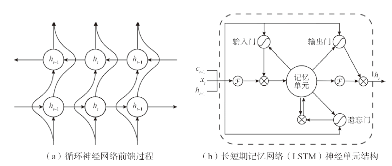
图8 关联统计循环神经网络 图中主要反映循环神经网络的数据流过程。其中,ht-1为第t-1时刻的隐藏层状态,ct-1为第t-1时刻记忆单元状态,xt为第t时刻的输入。
| 网络类型 | 网络结构 | 相关研究 |
|---|---|---|
| 关联统计神经网络 | CNNs | 厄尔尼诺预测[ |
| RNNs | 海表温度预测[ |
表1 部分关联统计神经网络在中层海洋遥感上的应用
| 网络类型 | 网络结构 | 相关研究 |
|---|---|---|
| 关联统计神经网络 | CNNs | 厄尔尼诺预测[ |
| RNNs | 海表温度预测[ |

图9 物理牵引神经网络的先验知识嵌入机制 依次通过基于数据的观察牵引、神经网络的归纳牵引和偏微分方程与损失函数的学习牵引,并进行反复迭代训练,最终实现物理牵引。
| 网络类型 | 牵引方式 | 相关研究 |
|---|---|---|
| 物理牵引神经网络 | 观察牵引 | 海洋次表层温度预测[ |
| 归纳牵引 | 海洋湍流预测[ |
表2 部分物理牵引神经网络在海洋科学上的应用
| 网络类型 | 牵引方式 | 相关研究 |
|---|---|---|
| 物理牵引神经网络 | 观察牵引 | 海洋次表层温度预测[ |
| 归纳牵引 | 海洋湍流预测[ |

图10 Ekman螺旋示意图(a)与全球气候态海面风场分布图(b)

图11 海洋内波

图12 基于BP(Back Propagation)神经网络的海洋内波预测结果

图13 高度计涡旋探测及识别结果

图14 高度计与Argo涡旋识别对比图
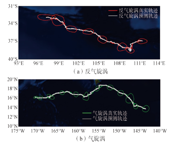
图15 基于物理嵌入算法的长寿涡轨迹预测结果
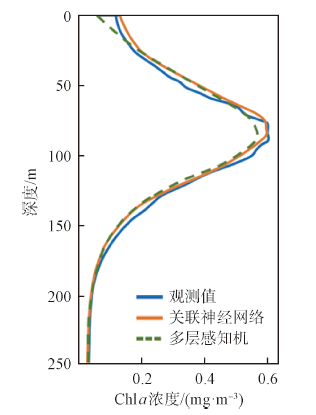
图16 北太平洋区域SCM反演结果
| [1] |
Ham Y G, Kim J H, Luo J J. Deep learning for multi-year ENSO forecast[J]. Nature, 2019, 573(7775): 568-572.
DOI URL |
| [2] |
Zhang X, Wang H, Wang S, et al. Oceanic internal wave amplitude retrieval from satellite images based on a data-driven transfer learning model[J]. Remote Sensing of Environment, 2022, doi: 10.1016/j.rse.2022.112940.
DOI |
| [3] | 陈戈, 杨杰, 田丰林, 等. 海洋涡旋遥感: 进展与挑战[J]. 遥感学报, 2021, 25(1): 302-322. |
| [4] |
Hostetler C A, Behrenfeld M J, Hu Y, et al. Spaceborne lidar in the study of marine systems[J]. Annual Review of Marine Science, 2018, 10: 121-147.
DOI PMID |
| [5] |
Churnside J H. Review of profiling oceanographic lidar[J]. Optical Engineering, 2013, doi: 10.1117/1.OE.53.5.051405.
DOI |
| [6] |
Behrenfeld M J, Gaube P, Penna A D, et al. Global satellite-observed daily vertical migrations of ocean animals[J]. Nature, 2019, 576(7786): 257-261.
DOI URL |
| [7] |
Behrenfeld M J, Hu Y, O, Malley R T, et al. Annual boom-bust cycles of polar phytoplankton biomass revealed by space-based lidar[J]. Nature Geoscience, 2017, 10(2): 118-122.
DOI URL |
| [8] |
Werdell P J, Behrenfeld M J, Bontempi P S, et al. The plankton, aerosol, cloud, ocean ecosystem mission: Status, science, advances[J]. Bulletin of the American Meteorological Society, 2019, 100(9): 1775-1794.
DOI |
| [9] |
Chepfer H, Noel V, Chiriaco M, et al. The potential of a multidecade spaceborne lidar record to constrain cloud feedback[J]. Journal of Geophysical Research: Atmospheres, 2018, 123(10): 5433-5454.
DOI URL |
| [10] |
Chen G, Tang J, Zhao C, et al. Concept design of the “Guanlan” science mission: China,s novel contribution to space oceanography[J]. Frontiers in Marine Science, 2019, doi: 10.3389/fmars.2019.00194.
DOI |
| [11] |
Chen P, Jamet C, Zhang Z, et al. Vertical distribution of subsurface phytoplankton layer in South China Sea using airborne lidar[J]. Remote Sensing of Environment, 2021, doi: 10.1016/j.rse.2021.112567.
DOI |
| [12] | Sprintall J, Cronin M F. Upper ocean vertical structure[M]// Steele J H. Encyclopedia of Ocean Sciences. 2nd ed. Oxford: Academic Press, 2009: 217-224. |
| [13] | Thurman H V. Essentials of oceanography[M]. Hoboken: Pearson Education, 2019. |
| [14] |
Riser S C, Freeland H J, Roemmich D, et al. Fifteen years of ocean observations with the global argo array[J]. Nature Climate Change, 2016, 6(2): 145-153.
DOI URL |
| [15] | 邱国强, 王海黎, 邢小罡. Bgc-argo浮标观测在海洋生物地球化学中的应用[J]. 厦门大学学报(自然科学版), 2018, 57(6): 827-840. |
| [16] |
Appenzeller T. The AI revolution in science[J]. Science, 2017, 357: 16-17.
DOI PMID |
| [17] | Huang G, Liu Z, Laurens V, et al. Densely connected convolutional networks[C]// Proceedings of the IEEE Conference on Computer Vision and Pattern Recognition. Piscataway: IEEE Press, 2017: 4700-4708. |
| [18] |
Simonyan K, Zisserman A. Very deep convolutional networks for large-scale image recognition[C]// The International Conference on Learning Representations. 2015, doi: 10.48550/arXiv.1409.1556.
DOI |
| [19] | Goodfellow I J, Pouget-Abadie J, Mirza M, et al. Generative adversarial nets[C]// The International Conference on Neural Information Processing Systems. 2014: 2672-2680. |
| [20] | He K, Zhang X, Ren S, et al. Deep residual learning for image recognition[C]// 2016 IEEE Conference on Computer Vision and Pattern Recognition. Piscataway: IEEE Press, 2016: 770-778. |
| [21] |
George T M, Manucharyan G E, Thompson A F. Deep learning to infer eddy heat fluxes from sea surface height patterns of mesoscale turbulence[J]. Nature Communications, 2021, doi: 10.1038/s41467-020-20779-9.
DOI |
| [22] |
Andersson T R, Hosking J S, Pérez-Ortiz M, et al. Seasonal arctic sea ice forecasting with probabilistic deep learning[J]. Nature Communications, 2021, doi: 10.1038/s41467-021-25257-4.
DOI |
| [23] |
Chen X, Chen G, Ge L, et al. Global oceanic eddy identification: A deep learning method from argo profiles and altimetry data[J]. Frontiers in Marine Science, 2021, doi: 10.3389/fmars.2021.646926.
DOI |
| [24] |
Xie J, Zhang J, Yu J, et al. An adaptive scale sea surface temperature predicting method based on deep learning with attention mechanism[J]. IEEE Geoscience and Remote Sensing Letters, 2020, 17(5): 740-744.
DOI URL |
| [25] |
Accarino G, Chiarelli M, Fiore S, et al. A multi-model architecture based on long short-term memory neural networks for multi-step sea level forecasting[J]. Future Generation Computer Systems, 2021, doi: 10.1016/j.future.2021.05.008.
DOI |
| [26] |
Su H, Wang A, Zhang T, et al. Super-resolution of subsurface temperature field from remote sensing observations based on machine learning[J]. International Journal of Applied Earth Observation and Geoinformation, 2021, doi: 10.1016/j.jag.2021.102440.
DOI |
| [27] |
Raissi M, Perdikaris P, Karniadakis G E. Physics-informed neural networks: A deep learning framework for solving forward and inverse problems involving nonlinear partial differential equations[J]. Journal of Computational Physics, 2019, 378: 686-707.
DOI |
| [28] |
Karniadakis G E, Kevrekidis I G, Lu L, et al. Physics-informed machine learning[J]. Nature Reviews Physics, 2021, 3(6): 422-440.
DOI URL |
| [29] | Meng Y, Rigall E, Chen X, et al. Physics-guided generative adversarial networks for sea subsurface temperature prediction[J]. IEEE Transactions on Neural Networks and Learning Systems, 2021 (Early Access). |
| [30] |
Wang R, Walters R, Yu R. Incorporating symmetry into deep dynamics models for improved generalization[C]// International Conference on Learning Representations. 2021, doi: 10.48550/arXiv.2002.03061.
DOI |
| [31] |
Liu Y, Zheng Q, Li X. Characteristics of global ocean abnormal mesoscale eddies derived from the fusion of sea surface height and temperature data by deep learning[J]. Geophysical Research Letters, 2021, doi: 10.1029/2021GL094772.
DOI |
| [32] |
Huang B, Ge L, Chen X, et al. Vertical structure-based classification of oceanic eddy using 3-d convolutional neural network[J]. IEEE Transactions on Geoscience and Remote Sensing, 2022, doi: 10.1109/TGRS.2021.3103251.
DOI |
| [33] |
Cranmer M, Greydanus S, Hoyer S, et al. Lagrangian neural networks[C]// International Conference on Learning Representations. 2020, doi: 10.48550/arXiv.2003.04630.
DOI |
| [34] |
Xiong S, Tong Y, He X, et al. Nonseparable symplectic neural networks[C]// International Conference on Learning Representations. 2022, doi: 10.48550/arXiv.2010.12636.
DOI |
| [35] | Wojtowytsch W E S. On the banach spaces associated with multi-layer relu networks: Function representation, approximation theory and gradient descent dynamics[J]. CSIAM Transactions on Applied Mathematics, 2020, 1(3): 387-440. |
| [36] |
Lei N. A geometric understanding of deep learning[J]. Engineering, 2020, 6(3): 361-374.
DOI URL |
| [37] | Lagerloef G S E, Mitchum G, Lukas R, et al. Tropical pacific near-surface currents estimated from altimeter, wind, and drifter data[J]. Journal of Geophysical Research: Oceans, 1999, 104: 23313-23326. |
| [38] |
Li X, Liu B, Zheng G, et al. Deep-learning-based information mining from ocean remote-sensing imagery[J]. National Science Review, 2020, 7(10): 1584-1605.
DOI URL |
| [39] | Zheng Q, Yuan Y, Klemas V, et al. Theoretical expression for an ocean internal soliton synthetic aperture radar image and determination of the soliton characteristic half width[J]. Journal of Geophysical Research: Oceans, 2001, 106(C12): 31415-31423. |
| [40] | Magalhães J M, Alpers W, Santos-Ferreira A M, et al. Surface wave breaking caused by internal solitary waves[J]. Oceanography, 2021, 34(2): 166-176. |
| [41] |
Zhang X, Li X, Zheng Q. A machine-learning model for forecasting internal wave propagation in the andaman sea[J]. IEEE Journal of Selected Topics in Applied Earth Observations and Remote Sensing, 2021, 14: 3095-3106.
DOI URL |
| [42] |
Pegliasco C, Delepoulle A, Mason E, et al. Meta3.1exp: A new global mesoscale eddy trajectory atlas derived from altimetry[J]. Earth System Science Data, 2022, 14(3): 1087-1107.
DOI URL |
| [43] |
Zhang Z, Wang Y, Qiu B. Oceanic mass transport by mesoscale eddies[J]. Science, 2014, 345(6194): 322-324.
DOI URL |
| [44] |
Chaigneau A, Le Texier M, Eldin G, et al. Vertical structure of mesoscale eddies in the eastern south pacific ocean: A composite analysis from altimetry and argo profiling floats[J]. Journal of Geophysical Research: Oceans, 2011, doi: 10.1029/2011JC007134.
DOI |
| [45] |
Amores A, Jordà G, Arsouze T, et al. Up to what extent can we characterize ocean eddies using present-day gridded altimetric products?[J]. Journal of Geophysical Research: Oceans, 2018, 123(10): 7220-7236.
DOI URL |
| [46] |
Chen G, Chen X, Huang B. Independent eddy identification with profiling argo as calibrated by altimetry[J]. Journal of Geophysical Research: Oceans, 2021, doi: 10.1029/2020JC016729.
DOI |
| [47] |
Chen G, Chen X, Cao C. Divergence and dispersion of global eddy propagation from satellite altimetry[J]. Journal of Physical Oceanography, 2022, 52(4): 705-722.
DOI URL |
| [48] |
Chelton D, Deszoeke R, Schlax M, et al. Geographical variability of the first baroclinic rossby radius of deformation[J]. Journal of Physical Oceanography, 1998, 28(3): 433-460.
DOI URL |
| [49] |
Wang X, Wang X, Yu M, et al. MesoGRU: Deep learning framework for mesoscale eddy trajectory prediction[J]. IEEE Geoscience and Remote Sensing Letters, 2021, doi: 10.1109/LGRS.2021.3087835.
DOI |
| [50] |
Li J, Wang G, Xue H, et al. A simple predictive model for the eddy propagation trajectory in the northern south china sea[J]. Ocean Science, 2019, 15(2): 401-412.
DOI URL |
| [51] |
Uitz J, Claustre H, Morel A, et al. Vertical distribution of phytoplankton communities in open oocean: An assessment based on surface chlorophyll[J]. Journal of Geophysical Research, 2006, doi: 10.1029/2005JC003207.
DOI |
| [52] |
Cornec M, Laxenaire R, Speich S, et al. Impact of mesoscale eddies on deep chlorophyll maxima[J]. Geophysical Research Letters, 2021, doi: 10.1029/2021GL093470.
DOI |
| [53] |
Chen J, Gong X, Guo X, et al. Improved perceptron of subsurface chlorophyll maxima by a deep neural network: A case study with bgc-argo float data in the northwestern pacific ocean[J]. Remote Sensing, 2022, doi: 10.3390/rs14030632.
DOI |
| No related articles found! |
| 阅读次数 | ||||||
|
全文 |
|
|||||
|
摘要 |
|
|||||


京公网安备 11010802038735号

